📐 Survey Topography Plan Greece – The Complete Guide by Samos Housing

🗺️ Survey topography plan Greece – essential for any property transaction

💰 Engineering and property valuation services Greece – professional and accurate
Planning to buy, sell or build on a property in Greece? A certified survey topography plan Greece law requires is your very first step — without it, no sale, no building permit and no construction can legally proceed. Samos Housing produces professional survey topography plans, 3D LIDAR building mapping, Electronic Building IDs, building inspections and Greek cadastre registrations across Samos Island and throughout Greece.
📏 What Is a Survey Topography Plan or Topograhic Plan in Greece?
A survey topography plan Greece — also called a land survey Greece, site plan Greece or topographic plan Greece — is an official technical drawing of your property produced by a licensed engineer. It maps the exact size, shape, GPS boundaries, neighbouring properties, terrain contours and all significant land features of your plot. In Greece, every survey plan must be produced using the EGSA 87 coordinate system — the official Greek Geodetic Reference System — and must be signed and stamped by a licensed civil engineer or surveying engineer.
Modern Topographic plans go far beyond a simple sketch. They identify forest zones, water streams, road setbacks, archaeological buffer zones and every feature that directly affects the building capacity of the land. As a result, the topography plan is the foundation document of every property transaction and construction project in Greece — everything else follows from it.
⚖️ When Is a Survey Topographic Plan in Greece Required?
Greek law makes a current survey topographic plan Greece with EGSA 87 GPS coordinates mandatory in a wide range of situations. The Greek Ministry of Environment and Energy sets and enforces all specifications that licensed engineers must follow. Specifically, a certified land plan is required for:
- 🏠 Selling any property in Greece — land, house or both; mandatory since 2012, with updated GPS coordinates required since 2022.
- 🔨 Applying for a building permit Greece — the e-adeies digital permit platform does not accept any application without a current topography plan.
- 📋 Legalising unauthorised construction — a survey plan is consequently the mandatory first step of any regularisation. See our construction and permits page for full details.
- 🏛️ Greek cadastre registration — the Hellenic Cadastre requires GPS-certified boundary plans for all submissions.
- 🆔 Obtaining the Electronic Building ID Greece — mandatory for all properties sold in Greece from April 2022.
- ✂️ Subdivision or consolidation of plots — any change to land boundaries therefore requires a new certified plan.
- 📜 Inheritance and property transfers — notaries require a current land plan Greece before signing any deed.
- 💳 Mortgage applications — Greek banks require a current topographic plan Greece as part of the property valuation file.
📐 What the Plan Actually Shows
- 📍 Exact boundaries and GPS coordinates — in the EGSA 87 Greek coordinate system, the legal standard for all property records in Greece.
- 📏 Plot area in square metres — the legally binding size used in all contracts, permits and tax declarations.
- 🏘️ Neighbouring properties and roads — with distances and legal setbacks from every boundary.
- 🏔️ Terrain contours and elevation — essential for construction design, drainage and structural engineering.
- 🌲 Forest zones and stream buffers — any legally restricted areas that reduce or eliminate building rights. You can moreover check indicative forest zone boundaries on the Hellenic Cadastre Forest Map viewer, though only a licensed engineer can issue a formal forest characterisation.
- 🏙️ Building zone classification — confirms whether the plot falls inside or outside the urban plan, directly determining what can be built.
- 🏗️ Existing structures — footprints of any buildings already on the plot, cross-referenced against the building permits.
🔧 Our Equipment & Technology
The foundation of all our engineering services starts with a precise survey topography plan Greece produced using our own professional equipment. Specifically, we use electronic Theodolites, modern LIDAR 3D mapping systems and electronic GPS surveying equipment. Every measurement is consequently taken in the EGSA 87 coordinate system, ensuring full compliance with Greek standards and Ministry of Environment specifications.
Moreover, this combination of technologies allows us to deliver a level of precision that goes far beyond a standard boundary survey. Whether you need GPS geolocation of a rural plot, a full 3D model of an existing building, or a detailed contour height map for an architectural project, our team is fully equipped to handle it. All outputs are directly usable in building permit applications, construction planning and architectural design.
🎯 3D LIDAR Building Survey Greece – Complete Building Mapping
In addition to standard land surveys, Samos Housing offers complete 3D LIDAR building surveys Greece. This service captures the precise geometry of any structure — walls, floors, roofs, openings and structural elements — producing a highly accurate digital model of the building as it actually exists today. As a result, it eliminates guesswork and costly errors at every stage of the project.
This LIDAR building mapping Greece service is particularly valuable in several situations common on Samos Island and throughout Greece:
- 🔄 Renovation and restoration projects — accurate as-built drawings are required before any renovation permit can be submitted. Furthermore, LIDAR mapping eliminates measurement errors at the design stage.
- 📜 Legalisation of older buildings — many properties in Greece were built before modern permit requirements. Consequently, a precise LIDAR survey of the existing structure is the starting point for any regularisation process.
- 🏗️ Architectural planning for extensions — before designing an addition or new floor, architects need an accurate record of the existing building. Our 3D models therefore integrate directly with architectural software.
- 🆔 Electronic Building ID Greece production — a detailed building survey accelerates the mandatory Electronic Building ID (Ταυτότητα Κτιρίου) and ensures it is complete and accurate.
- 🏛️ Heritage and stone buildings — Samos has many traditional stone houses with highly irregular geometry. LIDAR captures every curve and irregularity with millimetre precision — something impossible with manual measurement alone.
Combined with our GPS land survey, LIDAR building mapping gives you a complete picture of both the plot and everything on it — the most thorough starting point possible for any property project in Greece.
🌍 Samos Island – A Special Case
On Samos Island, the Hellenic Cadastre land registry is still being completed. Samos Town and surrounding areas were finalised in 2016, but many rural villages remain unregistered. As a result, in these unregistered zones a certified survey plan Samos with EGSA 87 GPS coordinates is the primary legal document securing your property boundaries. Without it, your plot has no formal legal definition in the national system.
Furthermore, rural properties on Samos frequently share informal boundaries with forest zones, water streams or neighbouring plots. A professionally produced topographic survey Greece reveals all of these features clearly — protecting buyers from costly future disputes and ensuring full legal compliance before any contract is signed. In particular, many properties on the island sit partially within forest buffer zones, something that only a certified survey can formally establish.
The Hellenic Cadastre expects Samos to be fully registered by approximately 2028. Properties in already-completed cadastre zones consequently offer stronger boundary security, especially for rural and agricultural land. Samos Housing therefore strongly advises all unregistered property owners to act as soon as possible — the window is closing. If you are also considering a certified property valuation, registering first will directly strengthen your valuation file.
🆔 Electronic Building ID Greece (Ταυτότητα Κτιρίου)
From April 2022, every building sold in Greece must have an Electronic Building ID Greece — known in Greek as Ταυτότητα Κτιρίου. This is a comprehensive legal and technical dossier covering the complete history of the property. Specifically, it includes all building permits, architectural drawings, ownership history, legal compliance status and a cross-referenced on-site inspection by a licensed engineer. You can read the full legislative background on the Greek Ministry of Environment and Energy portal.
The Electronic Building ID is stored on the official government platform buildingcert.gr and issued with a unique QR code. Both the seller and the buyer therefore receive a certified copy at the time of the notarial deed. Without it, any notary in Greece is legally prohibited from completing the sale — regardless of how long the property has been owned or how straightforward the transaction appears.
- 📂 What it contains: Building permits, architectural plans, energy performance certificate, structural reports, ownership records and on-site inspection findings.
- 👥 Who needs it: Every seller of any building in Greece — residential, commercial or mixed-use.
- 🌐 Government platform: buildingcert.gr — the official registry where all IDs are stored and publicly verified.
- ⏱️ Timeframe: Typically 2–4 weeks, depending on the availability of existing permit documentation.
🔍 Building Inspection Greece – Pre-Purchase Engineering Report
Found a property you want to buy? Before signing anything, commission an independent building inspection Greece. This is standard practice in Northern Europe and the UK — yet many foreign buyers skip it entirely when purchasing in Greece, often at significant cost later. Our licensed civil engineers consequently conduct an on-site visit and produce a detailed written report covering all critical aspects of the building and plot. Furthermore, if you are also considering a certified valuation, an inspection and valuation together give you the most complete picture before committing.
- 🏗️ Structural integrity — foundations, load-bearing walls, roof structure and frame condition.
- 💧 Humidity, damp and mould — water ingress, rising damp and ventilation deficiencies.
- 🏠 Roofing condition — tiles, waterproofing membranes, gutters and drainage systems.
- ⚖️ Legal compliance — comparison of the building's actual footprint against the original permit drawings.
- 🔄 Renovation and expansion potential — what is legally and structurally possible within current planning rules. See also our construction and renovation services.
- 🛠️ Maintenance roadmap — a prioritised list of works needed in the short, medium and long term.
📋 Greek Cadastre Registration – Hellenic Cadastre Property Registration
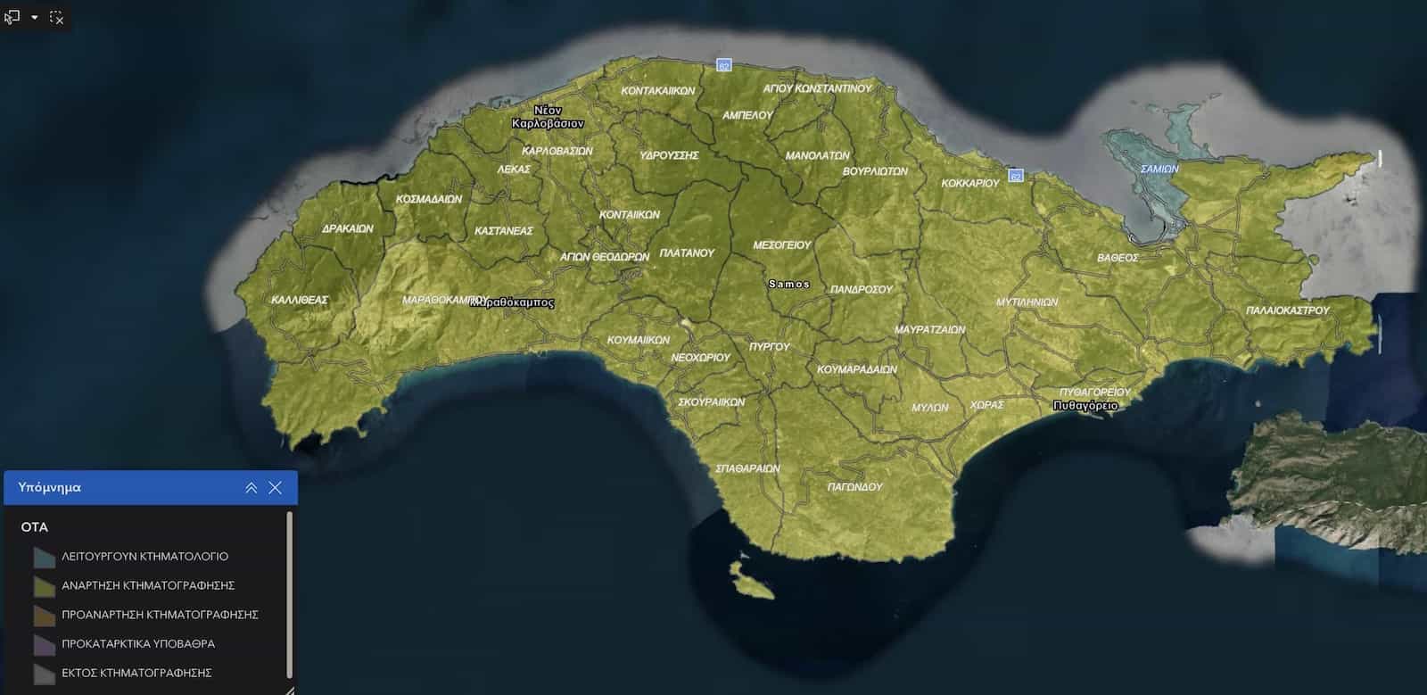
🏛️ Samos Cadastre Land Registry System — yellow boundary indicates completed registration areas
The Hellenic Cadastre (Κτηματολόγιο) is the official national land registry of Greece, recording the legal ownership, boundaries and rights of every property in the country. Greek cadastre registration is compulsory for all property owners — and on Samos, the registration window is still open in many areas, though it is closing fast as completion progresses toward 2028.
Unregistered properties carry serious legal risk. They cannot be sold, mortgaged or transferred without first completing Hellenic cadastre property registration. You can check whether your area has been completed using the Hellenic Cadastre GIS viewer. Samos Housing therefore handles the entire submission process on your behalf — correctly, safely and with full transparency at every step.
🎯 Step by Step – How Registration Works
- 📐 Step 1 – Boundary survey: We GPS-survey the exact boundaries of your property on site using our own equipment.
- 📏 Step 2 – New EGSA 87 survey plan (if needed): If your plan predates 2012 or lacks GPS coordinates, we consequently produce a new certified plan.
- 📄 Step 3 – Document preparation: We compile all required documents for submission to the Hellenic Cadastre.
- 📥 Step 4 – Cadastre submission: We submit the complete file on your behalf and manage any follow-up queries from the cadastre office.
- ✅ Step 5 – Confirmation: You finally receive your official cadastre registration number (ΚΑΕК) — your property is formally registered.
📋 Documents You Will Need
- 📜 The most recent deed of your property.
- 🔨 The existing building permit (if a building exists on the plot).
- 🗺️ Any existing survey plan — even an older one without GPS coordinates.
- 📍 Knowledge of the approximate boundaries — you or a family member must be able to identify the plot on site.
Contact us for a specific quote based on your property's size, location and existing documentation.
💼 Services & Starting Prices
| Service | Starting Price | Who Needs It |
|---|---|---|
| 📏 Survey Topography Plan Greece (GPS) | €250 + VAT | Sellers, buyers, builders |
| 🏔️ Topographic Survey with Contours & Heights | On request | Construction & architecture projects |
| 🎯 3D LIDAR Building Survey Greece | On request | Renovation, legalisation, architecture |
| 🆔 Electronic Building ID Greece | €500 + VAT + €20 gov fee | All property sellers in Greece |
| 🔍 Pre-Purchase Building Inspection Greece | €350 + VAT | Foreign buyers, investors |
| 🏛️ Greek Cadastre Registration Service | On request | All unregistered property owners |
| 🏗️ Construction Feasibility Report | On request | Plot buyers, developers |
🤝 Why Work With Samos Housing?
Samos Housing is the only full-service real estate and engineering agency based permanently on Samos Island. Unlike mainland or multi-island firms, we know every village, every road, every cadastre zone and every local planning regulation on the island. Our in-house team combines licensed civil engineers, certified property valuers and experienced real estate agents — consequently giving you a single trusted point of contact for every step of your property journey in Greece.
- ✅ In-house licensed surveying team with own Theodolite, LIDAR and GPS equipment.
- ✅ All survey topography plans Greece produced in EGSA 87 to Ministry of Environment specifications.
- ✅ 3D LIDAR building mapping for renovation, legalisation and architectural projects.
- ✅ Certified property valuations Greece — PeopleCert accredited.
- ✅ Full Hellenic Cadastre registration service on Samos.
- ✅ Electronic Building ID Greece via buildingcert.gr for all property types.
- ✅ Complete construction and building permit services on Samos Island.
- ✅ Full English-language service throughout — no language barrier at any stage.
- ✅ We work with EU and non-EU buyers, sellers and investors across all of Greece.
Ready to get started? Contact Samos Housing for a free initial consultation on your survey topography plan, LIDAR building survey, building inspection or cadastre registration needs anywhere in Greece.